
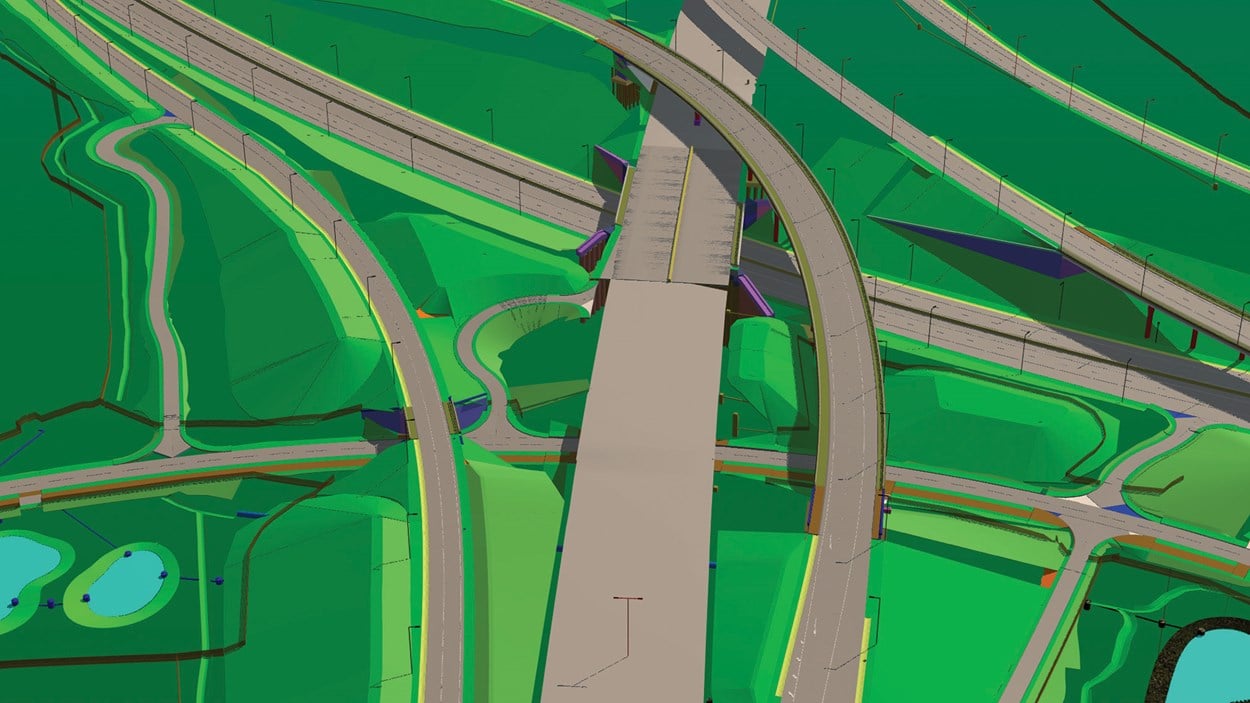
Our work in action: M1 Junction 19, Catthorpe Viaduct
The model for M1 Junction 19 is incredibly detailed. It includes all 750 piles that are required to support the three major road links and the three pedestrian bridges over minor roads. For each pile, the team used the BIM model to determine the optimum positions for the cranes and other machinery in relation to the rig, reducing plant movements and avoiding clashes with other contractors.
The visual planning is so detailed that stills from the visualisations have been used in place of phase diagrams. Changes to the design and programme occur frequently, as is to be expected on a large infrastructure project, but all adjustments are communicated easily as they are clearly reflected in the model. Field tools are used to access the model and other relevant documentation on the go, improving productivity by reducing reliance on printed documentation and eliminating the need for frequent trips to and from the site office.
Managing safety
Over 142,000 vehicles flow through the junction each day, so the schedule must be carefully planned to reduce safety risks – for road users, local people and site-based personnel.
An animation of the 22 construction phases has been developed and used to validate the proposed schedule, helping us to better plan for safety. This visualisation incorporates all site logistics including the 22 traffic switches – instances where the flow of traffic needs to be significantly re-routed.
Through the use of 3D machine control, which uses GPS positioning relative to digital terrain models, we have been able to reduce plant/people interface.
Building in green improvements
This project is one of the first where the Environmental Mitigation Plan has been integrated into the model. Any area on the site where the environmental team must be consulted prior to works taking place is clearly highlighted in the model. Some of the environmental issues are seasonal; they may relate to annual bird and bat migrations, for example. The model has been created so that these migration corridors are only shown during the migration season.
Another first is the integration of land ownership information. An overlay has been developed to display who owns each parcel of land in and around the project, from private landowners to government authorities. Community engagement has dramatically improved as our public relations teams can clearly identify which stakeholders will be affected at each phase.
All aspects of the M1 Junction 19 remodelling – from planning through to community engagement – is being managed more efficiently and effectively using a model that’s enriched with data on the schedule, cost, environment, safety and much more. It’s a way of working that helps to ensure that large, complex projects such as this are delivered on time, on budget and with minimum risk.
“A major benefit of BIM is that clashes have been detected early during the design phase which could otherwise have manifested into additional cost and programme implications during construction. Also BIM helps to visualise construction in 3D, particularly the interaction and phasing of this complex junction improvement, which would otherwise have been more difficult from a conventional set of drawings.”
Ivan Marriott, National Highways Project Manager, M1 Junction 19